Aleutians Uncrewed Ocean Exploration
A long-term survey around the Aleutian Islands and off the coast of California to address ocean exploration gaps in remote areas with USVs.
The Problem
The Aleutian Islands and surrounding Alaskan waters are among the most remote and least mapped parts of the US Exclusive Economic Zone, even though the region is a national priority for ocean exploration, habitat characterization, hazard assessment, and resource stewardship. Before this mission, only 31% of Alaska’s roughly 3.7 million square kilometers of ocean had been mapped to modern 100-meter standards.
Traditional ship-based mapping in the Aleutians is difficult, time-consuming, and expensive, and severe weather, persistent fog, and strong tidal currents make sustained operations especially challenging. The mission was designed to test whether a long-endurance uncrewed platform could close critical mapping gaps in this high-priority region while also collecting environmental DNA (eDNA) to improve understanding of marine biodiversity and ocean health.
Solution
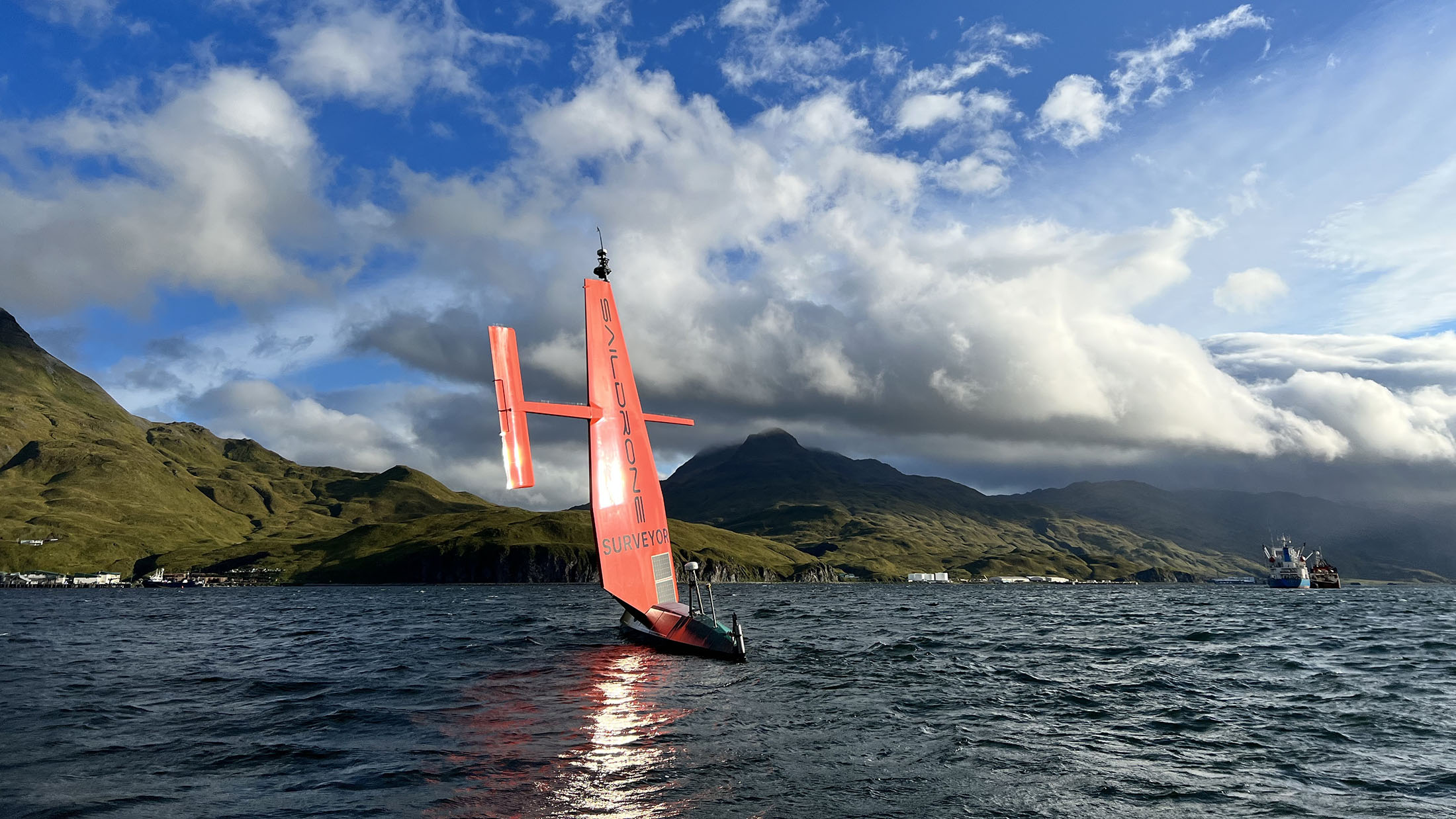
As part of the Aleutians Uncrewed Ocean Exploration expedition, Saildrone Surveyor SD-1200 was deployed through a multi-agency public-private partnership supported by NOAA and BOEM to collect ocean mapping and environmental data in unexplored waters around the Aleutian Islands, then continue on to additional priority areas off California.
Remotely operated from shore, the 20-meter Surveyor carried high-resolution mapping sonars and Monterey Bay Aquarium and Research Institute (MBARI)’s Environmental Sample Processor, an autonomous “lab in a can” that collects and preserves water samples for eDNA analysis related to marine biodiversity and ocean health.
Over 52 days between August and October, the vehicle conducted deep-ocean mapping in conditions including 35-knot winds and wave swells above 5 meters, demonstrating that an uncrewed system could safely gather high-quality data in waters that are operationally demanding for conventional survey missions.
Mission partners were able to monitor progress and data collection in near real time throughout the expedition.
Outcome
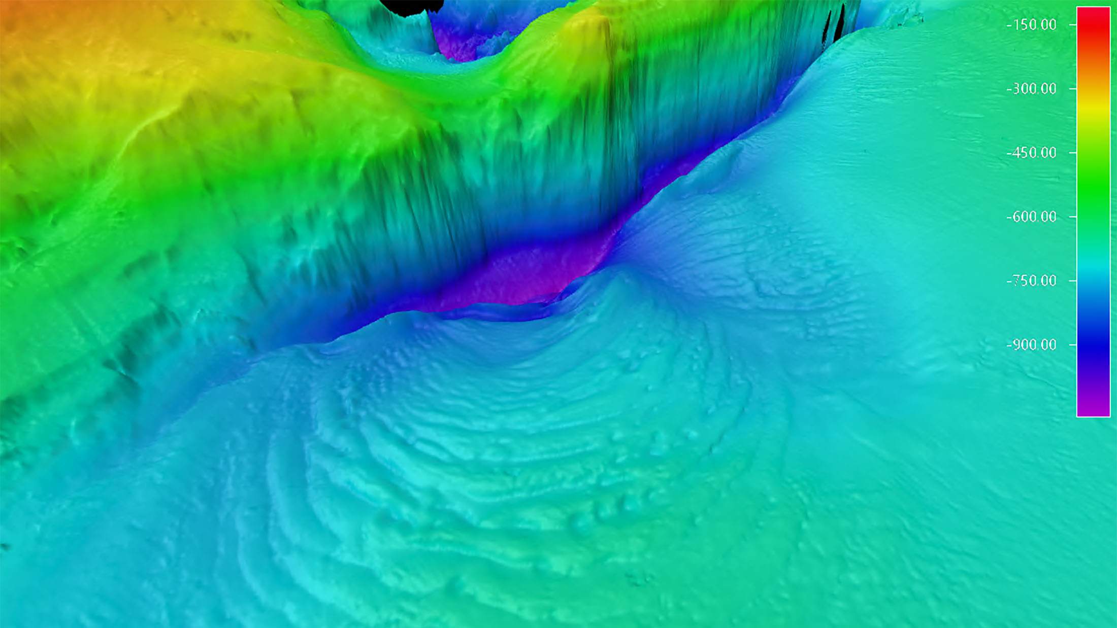
The mission mapped 4,738 square nautical miles (6,276 square miles) of previously unknown seafloor around the Aleutian Islands and revealed unprecedented detail of the Aleutian arc seabed, including previously unknown structures that suggested possible hydrothermal activity.
The Surveyor then mapped an additional 8,665 square nautical miles (11,474 square miles) of priority areas in the US EEZ off California, where it identified a previously unknown seamount rising about 1,000 meters from the seabed, less than 180 nautical miles northwest of San Francisco.
Beyond the discoveries themselves, the mission demonstrated that long-endurance USVs can accelerate, expand, and lower the cost of ocean exploration in remote waters. NOAA has said the publicly available data would support follow-on exploration, and later work in the Aleutian Arc explicitly built on features first identified by earlier Saildrone Surveyor mapping, including signs of hydrothermal activity and previously unknown seamounts.
Despite 35-knot winds and wave swells over 5 meters, the Surveyor continued to collect high-quality data without risk to human life and with a reduced carbon footprint.
“By joining forces with other federal agencies, academia, and industry, we were able to leverage a variety of expertise and multiple technologies to investigate areas off of Alaska and California that were otherwise unexplored. In order to map and characterize vast and remote expanses of the ocean, we need new technologies like the Saildrone Surveyor to augment ship-based exploration.”

Start Your Mission Today
Contact us now to discuss your mission requirements.