Published on
Author
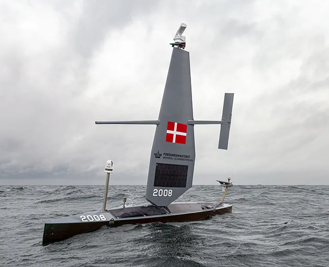
A fleet of Saildrone unmanned surface vehicles (USVs) is performing an integrated survey of the US West Coast this summer for NOAA Fisheries to collect data on commercially valuable hake and smaller coastal pelagic species. Fish stock surveys are traditionally carried out by ships equipped with trawl nets and/or echo sounders; this mission will allow scientists to evaluate the data collected by the saildrones and verify that the results compare favorably with current ship-based collection methods. This survey is the second of its kind, following a successful West Coast survey performed in 2018 in partnership with NOAA Fisheries and Fisheries and Oceans Canada (DFO).
In May, Saildrone launched six USVs from Dutch Harbor, AK, on a mission with NOAA/PMEL to survey ongoing changes in the Arctic ecosystem, including an acoustic survey of pollock in the Bering Sea. The seven USVs working collaboratively the West Coast survey now make up the largest regional saildrone fleet to date. This integrated survey consists of two sub-missions, each fulfilling a specific objective.

During the 2019 Hake Acoustic Survey for the Northwest Fisheries Science Center, four saildrones will duplicate transects performed by the NOAA ship Bell M. Shimada. The ship and the saildrones will start from Point Conception, just north of Santa Barbara, CA, and finish at the US-Canada border. The US and Canada have been conducting regular hake surveys since 1995. Fishery managers require data about the abundance of Pacific hake to make decisions about future harvests.
Three saildrones will augment ship-based efforts during the 2019 Coastal Pelagic Species Survey for the Southwest Fisheries Science Center, along with the NOAA ship Reuben Lasker. One of the saildrones will sample inshore waters too shallow for the Lasker to operate safely, while the other two saildrones will extend the survey area up to 200 nautical miles offshore. Coastal pelagic species like anchovy, herring, and sardines are an important food source for seabirds and marine mammals in the California Current ecosystem.
NOAA Fisheries is tasked with carrying out the mandates of the Magnuson-Stevens Fishery Conservation and Management Act in US federal waters. The act, which was first passed in 1976, aims to prevent overfishing, rebuild previously overfished stocks, increase long-term economic and social benefits, and ensure a safe and sustainable supply of seafood. Regular fish stock assessments are integral to achieving these goals.

Last year, Saildrone completed the first full West Coast survey, a 100-day mission from Vancouver Island to San Diego to collect data on fish and marine mammals from anchovy to humpback whales. Saildrone has or is collecting fisheries data in the Arctic, Antarctic, and North Sea.
Saildrones performing fisheries missions are equipped with Simrad echo sounders in addition to the standard sensor suite. These science-grade echo sounders send a sound pulse through the water and measure the sound waves echoing back from fish; fish abundance can be mapped as the saildrone makes repeated measurements moving through the water. Researchers can track the saildrones’ progress in real-time through an online mission portal.

The 2019 West Coast fisheries missions are expected to last approximately 60 days. Follow their progress at the Northwest Fisheries Science Center blog, The Main Deck.
Resources
Vicky Krikelas, “Evaluating capabilities of new technologies for the West Coast hake survey,” NOAA Northwest Fisheries Science Center, June 14, 2019