Improving Hurricane Rapid Intensification Forecasting
The biggest challenge to hurricane forecasting is rapid intensification, which can have a huge impact if a storm intensifies just before landfall.

The Problem
While NOAA has made steady progress in forecasting the track of a hurricane, forecasting hurricane rapid intensification—wind speeds increasing 30 knots in 24 hours or less—remains a significant challenge. To improve understanding of hurricane rapid intensification, scientists need to examine the ocean processes that occur as intensity increases, which means collecting data immediately before and during a storm.
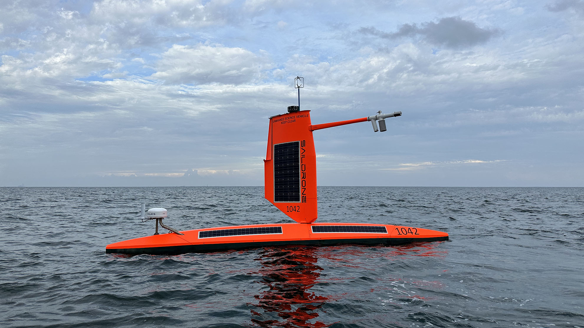
In 2021, NOAA and Saildrone launched a multiyear mission to deploy Explorer-class uncrewed surface vehicles (USVs) into tropical storms and hurricanes. The goal of the mission is to measure near-surface atmospheric and upper-ocean parameters to calculate energy and momentum fluxes between the atmosphere and the ocean, both outside and within hurricanes. The observations collected would be used to understand how ocean-atmosphere interactions affect hurricane intensity and to improve hurricane prediction models.
Solution
The vehicles are equipped with ruggedized “hurricane wings” designed especially for operating in winds over 78 knots and waves over 15.2 meters. They are strategically positioned in operational areas in the Tropical Atlantic and Gulf of America that have a high likelihood of encountering a hurricane, based on historical track data. NOAA and Saildrone Mission Control work together to task the vehicles into as many storms as possible.
The USVs transmit meteorological and oceanographic data, including air temperature and relative humidity, barometric pressure, wind speed and direction, water temperature and salinity, sea surface temperature, and wave height and period from the eastern tropical Atlantic in near real time; the NRT data is used to improve ocean-atmosphere initial conditions in forecast models.
During the missions, NOAA orchestrates coordinated sampling with underwater gliders and aerial assets to create a complete picture of the atmospheric and water column, from 9,000 meters above the surface to 1,000 meters below.
Outcome
All five vehicles in the 2021 mission contributed important insight into hurricane rapid intensification by sampling near various tropical storms. Individual drones sailed into and monitored Tropical Storm Henri, Tropical Depression Mindy, and Tropical Storms Fred and Peter. Another vehicle was positioned to the north of Tropical Storm Grace, and one successfully navigated the eye of Category 4 Hurricane Sam. Two of these drones also continued to sample the strong winds of Mindy after the storm had weakened to a post-tropical low.
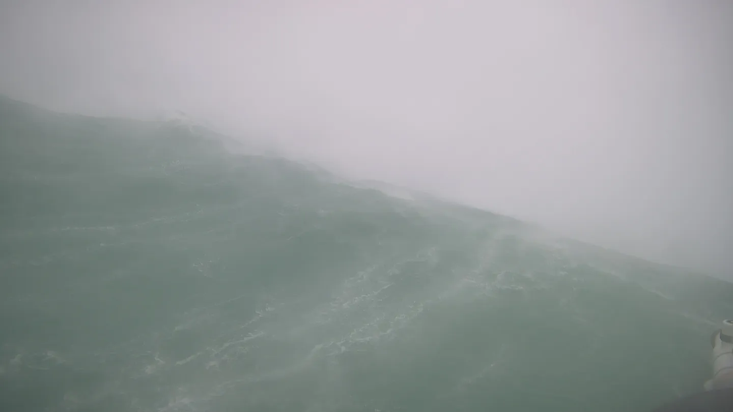
In 2022, four of the seven vehicles engaged with Hurricane Fiona. The storm was still a tropical storm when it passed over a vehicle stationed 400 nm east of Montserrat, where the drone measured wind gusts exceeding 34 knots. As Fiona tracked west and strengthened to a Category 1, it passed directly over a second vehicle stationed south of Puerto Rico. This drone recorded waves up to 14 meters and wind speeds over 61 knots, which dropped abruptly to 8.5 knots as the vehicle entered the eye of the storm. While inside the eye, it recorded a minimum central pressure of 986 mb.
Meanwhile, a third vehicle stationed north of Puerto Rico recorded 12-meter waves and wind speeds over 52 knots on the edge of the storm. By the time Fiona reached a fourth drone, it had intensified into a Category 4 storm. Navigating these extreme conditions, the vehicle maintained sustained speeds over 7.8 knots and reached a momentary peak speed of 34.5 knots before surfing down a massive 17-meter wave.
SD-1045, which sailed through the eye of Hurricane Sam in 2021, was entered into the Guinness Book of World Records as the highest windspeed captured by a USV—109.83 knots.
“The point of the whole scientific mission was to measure the surface flux within hurricanes, especially around the eyewall—and we got it! But before the mission began, my primary goal was to see if the new short-wing vehicle would work, because we just didn’t know. I told everyone, ‘If this vehicle can survive a hurricane, then this would be a big success story.’ The whole mission exceeded my expectations.”


Start Your Mission Today
Contact us now to discuss your mission requirements.