The third-annual Atlantic Hurricane mission will provide data to NOAA researchers to better understand how these large and destructive storms grow and intensify.
More Saildrones Than Ever Deploy for the 2023 Hurricane Season!
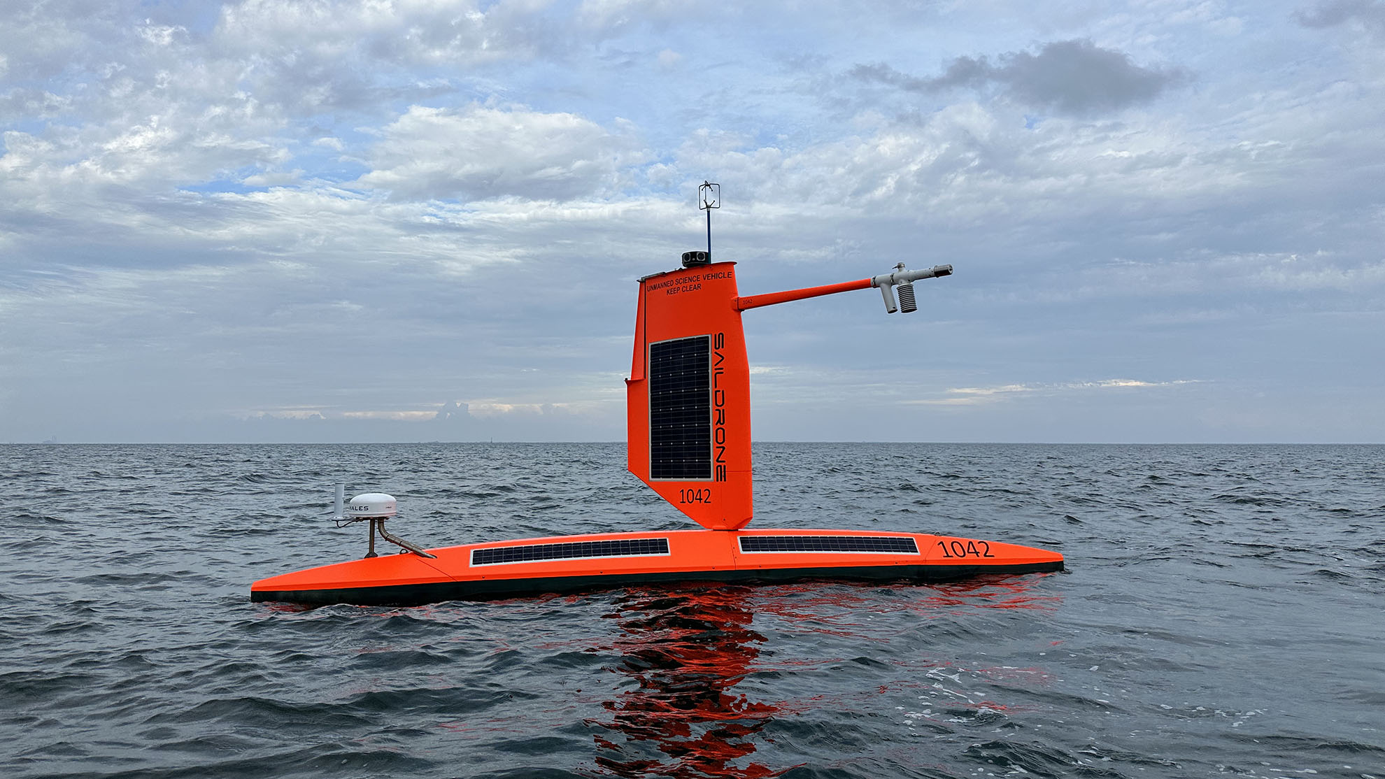
SD 1047 is one of 12 Saildrone Explorers equipped with a special “hurricane” wing that will collect data for the 2023 Atlantic Hurricane mission.
Published on
June 29, 2023
Read time:
5
Minutes
The National Oceanic and Atmospheric Administration (NOAA) predicts a “near normal” hurricane season—but it only takes one big storm to cause widespread damage to coastal communities.
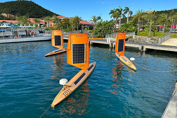
In partnership with NOAA, 12 Saildrone Explorers will be deployed throughout the mission—more than any Saildrone mission before. The vehicles will be storm chasing in the Tropical Atlantic and Gulf of Mexico to study why some relatively mild tropical storms rapidly intensify into major hurricanes, which is particularly destructive when it happens just before landfall.
Of all recorded weather disasters in the US, hurricanes have had the most significant impact: Between 1980 and 2021, hurricanes were responsible for over $1.1 trillion total in damages and 6,697 deaths.
“Rapid intensification, when hurricane winds strengthen by 35 mph or more in a matter of hours, can be a serious threat to coastal communities. The data provided by Saildrone and the other uncrewed systems that NOAA is using will help us better understand the physical forces that drive hurricanes, with the goal of more accurate forecasts and earlier warnings for communities,” said Greg Foltz, a NOAA scientist and one of the mission’s principal investigators.
A Saildrone Explorer is a 23-foot uncrewed surface vehicle (USV) propelled by the wind and powered by solar energy, with a zero operational carbon footprint. Saildrone has designed a shorter, more robust wing to withstand hurricane conditions—wind speeds over 75 mph and, more importantly, large breaking waves.

The USVs will be stationed in areas with a high probability of intercepting a storm, as indicated by historical data. The first 10 have already been or will soon be deployed from St. Thomas, US Virgin Islands, St. Petersburg, FL, and Charleston, SC. Two vehicles will remain on shore, ready for quick deployment in the event of an approaching hurricane.
The saildrones will collect metocean data, including air temperature and relative humidity, barometric pressure, wind speed and direction, water temperature and salinity, sea surface temperature, and wave height and period to scientists at NOAA’s Atlantic Oceanographic & Meteorological Laboratory (AOML) and Pacific Marine Environmental Laboratory (PMEL), Saildrone’s science partners in the mission.
“Saildrone is proud to support this critical research being conducted by our long-time partners at NOAA. It is an understatement to say that the ocean is a vast place, and we know relatively little about it. But the more vehicles we can deploy, the more data Saildrone can provide to address not only hurricane forecasting but other maritime challenges like illegal fishing, safety of life at sea, and safe navigation,” said Saildrone founder and CEO Richard Jenkins.
Wild conditions inside Category 4 Hurricane Fiona on Sept. 22, 2022.
A proven platform for hurricane data collection
This is the third year in a row Saildrone has deployed USVs to support NOAA’s hurricane research. In 2021, five vehicles were deployed to the Tropical Atlantic, and in 2022, seven vehicles were deployed, including two in the Gulf of Mexico.
During the past two missions, Saildrone vehicles sailed through several named storms and major hurricanes, including Hurricane Sam (2021) and Hurricane Fiona (2022), during which they captured video of the conditions inside the storm—winds gusting over 120 mph and waves up to 100 feet high. The video was relayed via satellite in near-real-time and shared with weather forecasters across the country, providing a new look at one of Earth’s most destructive forces.
“Saildrone is going where no research vessel has ever ventured, sailing right into the eye of the hurricane, gathering data that will transform our understanding of these powerful storms. After conquering the Arctic and the Southern Ocean, hurricanes were the last frontier for Saildrone survivability. We are proud to have engineered a vehicle capable of operating in the most extreme weather conditions on Earth,” said Jenkins after the 2021 mission.

All the tools NOAA is using to study hurricanes
Saildrone and NOAA kicked off the 2023 Atlantic Hurricane mission this week with an event at NOAA’s Aircraft Operations Center in Lakeland, FL, where all the tools NOAA uses to study hurricanes were displayed.
In addition to the Saildrone Explorers, NOAA is using a variety of aerial, surface, and sub-surface technologies to create a complete picture of the ocean-atmosphere interactions that drive hurricanes. The NOAA’s Hurricane Hunters are equipped with Tail Doppler Radar, which pinpoints where the strongest winds are located, how far they extend outward from a storm’s center, and the regions of heaviest rainfall, and a new remote sensing system. NOAA aircraft will also deploy expendable probes to take measurements as they descend through the atmosphere or water column. Small uncrewed aerial systems (sUAS) are used to sample the lowest and most dangerous regions of the hurricane—just a few hundred feet above the ocean.
Underwater gliders measure temperature and salinity to depths of 3,000 feet (1,000 meters), and drifters and Argo floats are already in place, monitoring the ocean year-round. During the mission, Saildrone USVs and gliders will be tasked to collect nearly collocated measurements of the upper air-sea interface and upper ocean.
NOAA Research will use the data collected by the Saildrone Explorers and other uncrewed systems to help improve hurricane forecast models. The data will also be archived by NOAA’s National Environmental Satellite, Data and Information Service (NESDIS) and sent by NOAA to the World Meteorological Organization (WMO)’s Global Telecommunication System (GTS), where it is available for the world’s major forecast centers—some 20 agencies worldwide, including NOAA.
Read more: A New Era of Hurricane Observing and Forecasting
For media assets or interview requests, use our media contact form.
Must Read


[
NEVER MISS AN UPDATE
]
Stay informed with the latest research findings and updates.
By clicking Sign Up you're confirming that you agree with our Privacy Policy.
