Published on
Author
The ocean is in constant motion: Winds, currents, and tides transport water, heat, carbon, and nutrients from the equator to the poles feeding a vast underwater ecosystem and driving the weather we experience on land. But water doesn’t just move around the planet, it also moves vertically, from the depths of the ocean to the surface, and from the surface to the depths.
The Sub-Mesoscale Ocean Dynamics Experiment (S-MODE) is an ambitious project led by scientists at NASA, Woods Hole Oceanographic Institution (WHOI), and the Applied Physics Laboratory at the University of Washington to understand how ocean whirlpools and eddies affect the vertical transport of heat, carbon, and nutrients that impact climate and are important for biological productivity. (Submesoscale refers to physical processes in the ocean that occur at dimensions less than six miles in diameter.)
The flow of water in the ocean is extremely complicated, and these small ocean eddies and whirlpools are intermittent and ephemeral, which makes them extremely difficult to measure.

“We’re ultimately working to better understand the ocean so that we can better simulate it in models—and that will lead to improvements in the way we make weather forecasts and understand the evolution of the climate and the ocean’s role in it,” said J. Tom Farrar, a scientist in the Department of Physical Oceanography at Woods Hole Oceanographic Institution and the mission’s principal investigator.
In October 2021, a wide variety of platforms were deployed from San Francisco including aircraft equipped with remote sensing equipment, the research vessel Oceanus, surface and underwater gliders, floats, and a group of five Saildrone Explorers. The experiment took place roughly 75 nautical miles off the coast of California, in the California Current system. The area is historically significant as the site of several early, influential studies of submesoscale variability.
For three weeks, a NASA Armstrong King Air B200 and a Twin Otter DHC6 airplane collected data from the sky about winds, currents, and waves, while the ship, saildrones, and other autonomous instruments collected in situ data from the ocean below. Aircraft (and satellites) can provide large spatial observations, but their instruments can’t see below the ocean surface. Saildrone Explorers are a proven platform for in situ data collection above and below the sea surface.

“The Pacific Ocean is about 2.5 miles deep on average, but it’s 10,000 miles wide. We’re looking at the surface mixed layer, which is only about the top 300 feet of ocean, so it’s really a very thin skin, but the ocean dynamics are really important for allowing—or not—the exchange of properties between the ocean and the atmosphere,” explained Farrar.
Vertical motion of water in the ocean is tied to the convergence and divergence of currents; as currents converge, water is pushed down into the depths, as it diverges, it pulls water up to the surface. It’s not possible to directly measure the vertical velocity of water flow with most platforms. Instead, scientists take measurements at different locations to calculate if the water flows are converging or diverging and the speed at which they’re moving to infer vertical velocity and direction.
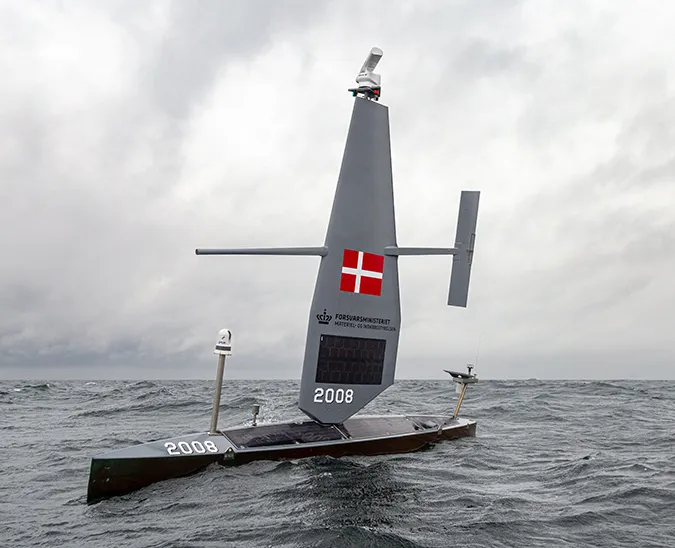
Saildrone Explorers are 23-foot autonomous vehicles propelled by the wind. Saildrones can be operated individually or as a fleet, sailing precise mission tracks or holding station. Formation sailing provides the high temporal and spatial resolution required to understand ocean and atmosphere dynamics. One goal of the mission was to sail the saildrone group in precise formations about .6 miles wide across features of interest to estimate at every instant of time whether the water flow was converging or diverging.

“During this campaign, we had a lot of weather and periods of very good sailing conditions. During those periods, we were quite successful with formation sailing, and we were able to perform a quincunx array (a pattern corresponding to the fifth side of a die), which has never been done before but it is an excellent formation to calculate velocity differences. We maintained that formation for 24 hours and it worked wonderfully,” said Cesar Rocha, assistant professor in the Department of Marine Sciences at the University of Connecticut and lead for the Saildrone aspect of the project.
Every platform has its limitations. During periods of light wind, the saildrone formations were harder to maintain. However, at the start of the mission, a bomb cyclone blew through the survey area bringing strong winds and waves over 30 feet high. The research vessel suffered some damage in the storm and had to return to port for several days, during which the saildrones were the only in situ instruments on the water.
“We were really glad to have the saildrones in the mix of instruments because at that point, they were our only source of information,” said Farrar. “The diversity of platforms creates an exciting investigation in oceanography and enables scientists to eke out every last bit of accuracy.”

S-MODE was a pilot campaign to test the platforms and ahead of larger campaigns next year. Future S-MODE field campaigns will take place in the fall when upwelling starts and in the spring when the surface mixed layer is at its greatest depth.
From the Saildrone Surveyor launch in January and its first Pacific mission in June to the first Saildrone deployment in the Great Lakes and the Atlantic hurricane mission throughout the fall, 2021 has been Saildrone’s busiest year on the water. S-MODE was not the only campaign Saildrone was working on with NASA: Two Saildrone Explorers spent nearly four months in the Arctic as part of NASA’s Multi-Sensor Improved Sea Surface Temperature Project (MISST).
Resources
Sofie Bates, “Instruments in the Sea and Sky: NASA’s S-MODE Mission Kicks off 1st Deployment,” NASA.gov, Oct. 21, 2021
Dragana Perkovic-Martin, “Liftoff! Aircraft Experiments Take Flight for NASA’s S-MODE Mission,” NASA Earth Expeditions blog, October 28, 2021