Five saildrones were deployed from Barbados to join the EUREC4A/ATOMIC project, a massive international effort using air, space, surface, and sub-surface platforms to improve climate models and weather prediction.
Saildrone Atlantic Fleet Studies Tropical Ocean-Atmosphere Interactions

Published on
January 16, 2020
Read time:
5
Minutes
Fluffy, white clouds against a deep blue sky hovering low over a turquoise ocean—it’s a typical day in the tropics. But how do those clouds form and why? Cloud formation in the atmosphere, particularly over the ocean, is closely linked to ocean processes, the transfer of heat and moisture. It’s a little-understood phenomenon of climate science—and one that could have a significant implication on climate modeling and weather prediction.
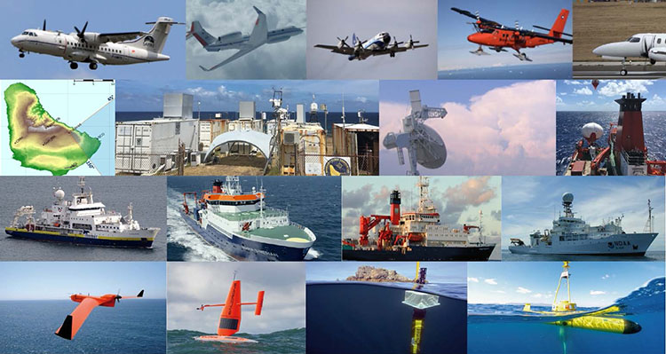
Two complementary international initiatives—EUREC4A (Elucidating the Role of Cloud-Circulation Coupling in Climate) and ATOMIC (Atlantic Tradewind Ocean-Atmosphere Mesoscale Interaction Campaign)—aim to advance the understanding of how the ocean and atmosphere interact. This massive coordinated effort between US and European science organizations includes a two-month field study using an impressive array of observing platforms: satellites, aircraft, research vessels, buoys, floats, drifters, autonomous underwater vehicles, and a fleet of Saildrone unmanned surface vehicles (USVs).
“When we think about climate change, we think about the temperature rising in the atmosphere, but actually, it’s the ocean that is changing,” said Dr. Sabrina Speich, a physical oceanographer at France’s Laboratoire de Météorologie Dynamique and one of EUREC4A’s principal investigators. “By improving our knowledge, we can improve the way we simulate this in models so that we can improve weather forecasts and predictions of extreme events.”
Five saildrones were deployed from Barbados to study tropical ocean-atmosphere interactions in the North Brazil Current. This is an extremely energetic region of the Western Atlantic where a warm water ocean current mixes with fresh water from the Amazon and Orinoco Rivers, forming some of Earth’s largest ocean eddies with strong temperature and salinity gradients. In the simplest terms, clouds represent energy transfer from the ocean to the atmosphere. Studying upper ocean processes can unlock the mysteries of tropical cloud formation.

The Saildrone fleet joins an international consortium of observational platforms: NASA and European Space Agency (ESA) satellites, research vehicles operated by NOAA, IFREMER (France), and the German Research Fleet Coordination Centre; aircraft provided by France, Germany, the United Kingdom, and US (NOAA); the Barbados Cloud Observatory; and Woods Hole Oceanographic Institution’s Northwest Tropical Atlantic Station (NTAS), as well as unmanned aerial and sub-surface vehicles, floats, and drifters. Working together, these platforms will capture a multidimensional picture of air-sea interactions in the Western Atlantic.
The saildrones will collect data at the ocean-air interface (i.e. the sea surface). Nearby, the German research vessel Maria S. Merian will fly a CloudKite carrying advanced microphysical instrumentation to look at marine boundary layer profiles and wind. At the same time, the ESA’s Aeolus satellite will use lasers to measure the wind profile to 1,000 meters (3,280) feet. The data combined from these three platforms will create a wind profile that extends from the outer layers of the atmosphere to the sea surface.
“The kite on the ship will look at how the wind speeds are changing as they approach the surface. With the saildrones, we’ll look at the impact of the wind on the waves and how that’s affecting the ocean. And we’ll use this tracking method across small gradients to look at how the fluxes respond,” explained Dr. Chelle Gentemann, a senior research scientist at The Farallon Institute.

In the past, the only way scientists have been able to look at air-sea fluxes is with large research vessels or highly instrumented buoy sites, which are in operation in only a handful of areas of the ocean and measure temporal resolution fluxes in a fixed location. Saildrones are mobile—wind-powered vehicles that autonomously navigate a set of waypoints. Routes can be updated on the fly to adapt to evolving mission objectives. A fleet of saildrones can provide a higher resolution picture than ever before of how the ocean and atmosphere respond to each other and adjust over small-scale variability.
“There are very few observing platforms capable of carrying the number of instruments that saildrones carry. The frequency of saildrone observations is really high, so they can continuously observe really small-scale structures in a region of the ocean that the ships cannot. Ships start observation of the atmosphere at about five to seven meters (16.5 to 23 feet) above the sea surface and five to seven meters below the surface. Saildrones can fill that gap. Of course, the saildrones are not just measuring the ocean but also the fluxes, which is where we are missing information. This will help us join the air and the water very well to complement the observation we do with other platforms,” said Speich.

The Saildrone platform is not a single-use vehicle; the data collected can be used to achieve several scientific objectives simultaneously. A second NASA satellite is studying salinity from space. Saildrone salinity observations will provide calibration and validation information for how satellites are measuring ocean salinity and strong salinity gradients, like those present in the North Brazil Current region.
The saildrone fleet will operate in two eddy corridors, in Easterlies Alley and southeast of BCO in the North Brazil Current ring, from January to July. Sensor payloads have been customized with instruments for air-sea interaction measurements at the ocean mesoscale and sub-mesoscales (10 meters to 300 kilometers/33 feet to 186 miles) to complement those of the EUREC4A and ATOMIC ship and air observation platforms.

To look closely at near-surface temperature gradients, three of the saildrones have been equipped with additional temperature sensors installed on the trailing edge of the keel to investigate temperature gradients in the upper 1.5 meters (4.9 feet) of the ocean. NASA scientists will be looking at the huge freshwater eddies present in the region to understand how small-scale variability in the ocean’s salinity and temperature affect the transfer of heat and moisture to the atmosphere, affecting cloud formation and driving weather.
“By integrating these observations and understanding the processes, using in complement a large spectrum of numerical simulation, it will lead us to improve the models that are used for weather forecasts, sub-seasonal forecasts, seasonal forecasts, and Earth system models,” said Speich.
Must Read


[
NEVER MISS AN UPDATE
]
Stay informed with the latest research findings and updates.
By clicking Sign Up you're confirming that you agree with our Privacy Policy.
