Saildrone Voyager USVs are mapping in the Gulf of Maine to support the NOAA deep-sea coral survey.
Saildrone Resumes Seafloor Mapping Mission in Gulf of Maine

Published on
April 3, 2024
Read time:
5
Minutes
Accurate ocean depths and seafloor topography are essential for navigation, resource management, tsunami forecasting, telecommunications, understanding weather and climate, managing environmental changes, and so much more. But only 23% of the global ocean has been mapped using modern, high-resolution tools, leaving substantial gaps in our knowledge about our oceans. This week, Saildrone is excited to kick off our first ocean mapping mission on the US East Coast.
Two Saildrone uncrewed surface vehicles (USVs) will return to the area where they spent two months last summer mapping in the north-central Gulf of Maine in support of National Oceanic and Atmospheric Administration (NOAA) deep-sea coral surveys. Prior to last year's mission, the area where they are operating in the Gulf of Maine was never before mapped in high resolution using modern tools.

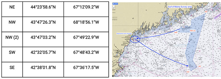
Vehicle locations and safety features
The two vehicles will be working in the same general section of the study area but could be 5 – 10 nautical miles apart from each other, surveying separate tracklines in adjacent blocks. Each vehicle will be operating in small portions of the total survey footprint, surveying one 2.7 nm x 2.7 nm square each day. The vehicles are beginning the survey at the southern end of the survey area and are progressing north.
The first two weeks of operations are scheduled to be conducted south of 43°N. As the survey progresses, updates on anticipated vehicle coordinates and areas completed will be published weekly on our blog. The total polygonal area of operation across the two-month mission is depicted in the chart and coordinates below.
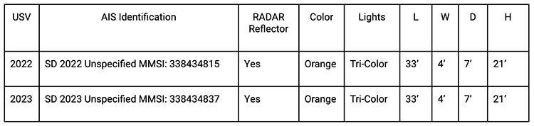
To ensure safe operations at sea, each vehicle is equipped with an Automatic Identification System (AIS) transceiver, enabling it to see and be seen by surrounding commercial traffic. The vehicles are slow relative to other marine users and operate at speeds between 2 – 4 knots, moving between a series of predetermined waypoints. They are designed with high visibility colors for daytime visibility, a bright navigation light for nighttime awareness, and are equipped with a radar reflector. Onboard cameras provide domain awareness to operators at Saildrone Mission Control and are monitored remotely 24/7.
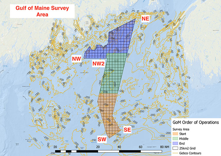
Vehicle operations for the week of July 1
Survey operations resumed in the Gulf of Maine are planned to be completed by July 10.
For the period of July 1 – July 9, Saildrone will have two vehicles collecting data in the survey blocks identified as follows and in the figure below:
Vehicle 1: Survey blocks 71, 108, 146, 185, 186, 223, and 224; bounding coordinates 43.69º N, 067.89º W; 43.59º N, 067.59º W
Vehicle 2: Survey blocks 219, 220, 221, 222, 255, 256, and 280; bounding coordinates 43.86º N, 067.65º W; 43.68º N, 067.47º W
Because Saildrone vehicles are dependent on wind for propulsion, actual survey progress will be dependent on environmental conditions. For planning purposes, we anticipate it will take one to two days to complete a survey block before proceeding to the next area.\

What is a Saildrone Voyager?
The Saildrone USVs being used for this mission are 10-meter (33-foot) Voyager-class vehicles. The Voyager is designed specifically for near-shore ocean and lakebed mapping. The Voyager carries a payload of science sensors and mapping echo sounders, as well as navigation and communications equipment, including AIS, radar, and cameras. The Saildrone Voyager is the only survey USV that can deliver long-duration International Hydrographic Organization (IHO)-compliant multibeam mapping surveys and ocean data collection at depths up to 300 meters (900 feet).
Saildrone USVs are primarily wind and solar powered, but the Voyager also carries a high-efficiency electric motor for speed and maneuverability in light winds, which makes it ideal for near-shore operations.
Saildrone has been operating autonomous data collection missions for ocean research, seafloor mapping, and maritime security since 2015. Earlier this year, Saildrone’s largest class of vehicle, the Saildrone Surveyor, completed a months-long survey around Alaska’s Aleutian Islands and off the coast of California, during which it discovered a previously unknown seamount standing approximately 1,000 meters (3,200 feet) high from the seabed. NOAA is also using a fleet of 7-meter (23-feet) Saildrone Explorers in the Tropical Atlantic and Gulf of Mexico to study hurricane rapid intensification. Combined, the Saildrone fleet has already spent more than 25,000 days at sea and sailed almost 1,000,000 nautical miles from the Arctic to the Antarctic.
Still have questions?
As the survey progresses, updates on Voyager locations will be shared weekly, via this article and the Saildrone Gulf of Maine mission hotline: (510) 980-6720.
For more specific information regarding the location of the vehicles or other questions about the mission, please contact Saildrone Program Manager Kitch Kennedy at kitch.kennedy@saildrone.com
For media inquiries, use our media contact form.
Must Read


[
NEVER MISS AN UPDATE
]
Stay informed with the latest research findings and updates.
By clicking Sign Up you're confirming that you agree with our Privacy Policy.
