Saildrone partnered with the University of Southern Mississippi and NOAA to complete our first shallow-water multibeam bathymetry mission in the Gulf of Mexico.
Shipwreck Discovered During Proof-of-Concept Multibeam Bathymetry Mission

Published on
September 4, 2019
Read time:
5
Minutes
An accurate map of the ocean bottom is necessary and vital to the global community. Not only is it important for navigation, but also for fisheries and habitat management, telecommunications, offshore energy, and understanding the ocean’s currents and the physical properties. In July, Saildrone partnered with the University of Southern Mississippi (USM) and the National Oceanic and Atmospheric Administration (NOAA) to launch a Saildrone unmanned surface vehicle (USV) equipped with a shallow-water multibeam echo sounder in the Gulf of Mexico to test the accuracy and longevity of the platform.
Early ocean mapping techniques involved a lead weight, a rope, and a sextant; modern bathymetry requires a large research vessel and a team of experts—an extremely expensive and time-consuming undertaking, further limited by fuel requirements, provisioning, and weather.

“The United States has vast areas of unsurveyed waters, particularly in the Western Pacific, the Arctic, and the Great Lakes. We cannot afford to conduct these surveys using traditional methods and are seeking technology that will allow us to increase our capacity for surveying over the coming decade,” said Rear Adm. Shep Smith, director of NOAA’s Office of Coast Survey.
SD 1024 spent 10 days sailing narrow transects in key areas of the gulf. Transect lines for multibeam bathymetry surveys are generally three to four times the bottom depth. The area of the Gulf of Mexico surveyed was approximately 20 meters (65 feet) deep; SD 1024’s transect lines were 60 – 80 meters (197 – 262 feet) apart. The mission was designed to show that the saildrone could steer accurately enough to conduct a multibeam survey in shallow water and that the saildrone power budget could handle the significant requirements of a multibeam system operating 24/7.
“I was very impressed by how well the Saildrone could drive in a straight line and maintain close proximity to the planned survey lines. Even during light winds, the navigation was excellent,” said Brian Connon, director of USM’s Hydrographic Science Research Center (HSRC).
The Gulf of Mexico is at the center of the field of bathymetry and it is regularly surveyed by a range of technologies for testing and data comparison. There is a vast archive of detailed data sets of the gulf floor, which makes it an ideal place for a proof-of-concept mission of Saildrone’s mapping capabilities.
“We found that after minimal post-processing, our data meets or exceeds the International Hydrographic Organization’s standards for safety of navigation surveys,” said Matt Paulson, program manager for single and multibeam bathymetry at Saildrone.
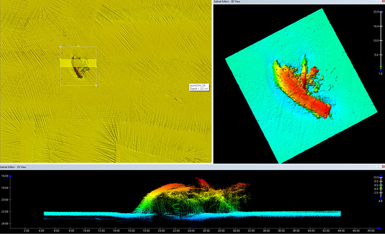
More than 600 shipwrecks have been located and documented in the Gulf of Mexico, though NOAA estimates that there could be more than 4,000. Some date to the 16th century, others are as recent as World War II. SD 1024’s survey area included two known shipwrecks, but during the mission, the saildrone discovered a third wreck that doesn’t appear on any chart.

“We discovered the wreck during post-processing of the multibeam sonar data collected during our second operational deployment. We compared the location of each of the three shipwrecks we found with current NOAA charts. Two of them were in the exact locations shown on the charts while the third was not depicted at all,” explained Paulson.
A multibeam echo sounder is made up of 512 beams of sound that bounce off the bottom of the seafloor up to 20 times per second and returning at different angles, which requires a far greater power supply than the typical Saildrone Generation 5 sensor suite. The sensors and computers onboard a saildrone are powered exclusively by solar power. In the current configuration, SD 1024 is able to collect up to 240 hours (10 days) of multibeam data; engineering teams are working to raise that limit to three to four weeks of consecutive multibeam data collection.
“These initial results show great promise for the use of saildrones to survey in remote areas of the world. There are many regions that haven’t been surveyed because they are either hard to reach, like the western Pacific islands, or only accessible during short periods, like the Arctic. Saildrone is a unique alternative to sending survey ships to these areas,” said Connon. “I fully expect saildrones to be an important participant in ocean mapping and hydrography in the near future. This is exciting technology and I am glad to be a part of the team working to make it operationally viable.”
Must Read


[
NEVER MISS AN UPDATE
]
Stay informed with the latest research findings and updates.
By clicking Sign Up you're confirming that you agree with our Privacy Policy.
