After suffering damage in a Gulf Stream storm, SD 1021 received a new wing in Bermuda and set out for the Solent on a mission to complete the fastest unmanned Atlantic crossing.
Saildrone Completes Fastest Atlantic Crossing by Unmanned Vehicle

Published on
August 8, 2019
Read time:
5
Minutes
Saildrones are not single-mission vehicles. They are designed for multiple deployments over their long lifespan. They may survey Alaska pollock in the Bering Sea and then track great white sharks across the Pacific Ocean. Or, after measuring carbon in the Chukchi Sea, they may head to the Southern Ocean to complete the first autonomous circumnavigation of Antarctica.
On its third mission, SD 1021 completed Saildrone’s first Atlantic crossing, sailing from Bermuda to the Solent in just 75 days.

The unmanned surface vehicle (USV) was first deployed in the summer of 2018, one of four saildrones that spent three months in the Arctic Ocean measuring carbon dioxide and the abundance of Arctic cod, in partnership with the National Oceanic and Atmospheric Administration (NOAA) Pacific Marine Environmental Laboratory (PMEL). The mission gathered data to identify ongoing changes in the Arctic ecosystem and study how those changes might affect the food web and large-scale weather systems.
Saildrones are deployed and recovered from any oceanside dock and are designed to fit into a shipping container for transit to any launch site. Once launched from a dock, they can make their own way to the area of study, returning for service at the end of the mission.
In early 2019, SD 1021 was shipped to Rhode Island for a 30-day mission to measure wintertime air-sea heat and carbon exchange in the Gulf Stream. The Gulf Stream is thought to be a hot spot for ocean carbon uptake, however, maximum CO2 flux occurs during the winter when intense weather conditions make ship-based in situ observations extremely difficult. After Leaving Newport, SD 1021 was hit by an arctic freeze, seeing temperatures of -8°C, which covered the vehicle in sea ice for several days. It was then battered by over 40-knot winds for the first three weeks and completed five crossings of the Gulf Stream, measuring heat and carbon content as it went. The mission, which was led by Dr. Jaime Palter of the University of Rhode Island and supported by a Saildrone Award, provided the most detailed data to date on the wintertime evolution of CO2 in the Gulf Stream.
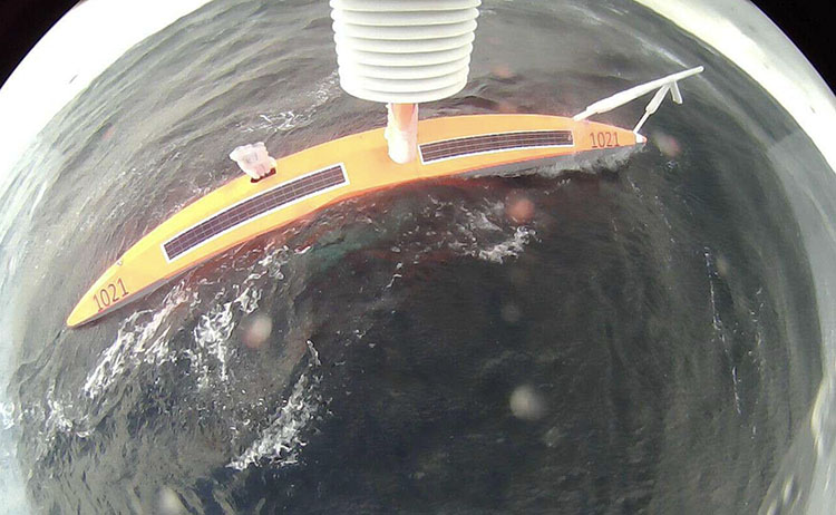
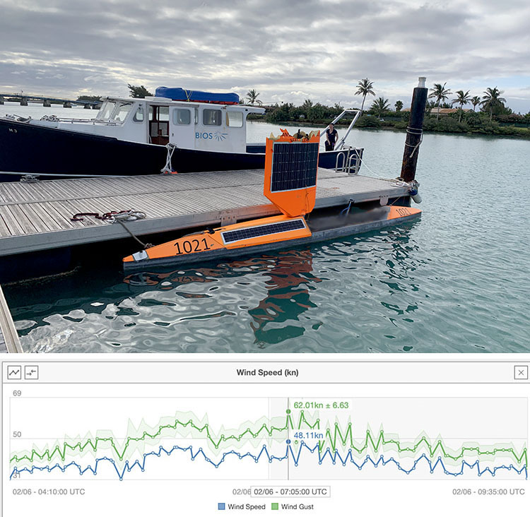
On February 26, the USV encountered an extreme storm with winds gusting to 58 knots (67 mph) and waves over 12 meters (40 feet) high. The vehicle did well for a while, but one rogue breaking wave submerged and rolled it, breaking the wing in half. Fortunately, saildrones have 100% redundancy. Backup systems took over and we navigated SD 1021 to the nearest landmass for repair. One month later, the Saildrone support crew met the vehicle in Bermuda. Many thanks to the team at the Bermuda Institute of Ocean Sciences (BIOS) for towing the vehicle into the harbor and allowing us to use the amazing facilities to fit the new wing!
“We’ve designed the saildrones to withstand the toughest conditions in the ocean—extremely low temperatures in the high latitudes in the Arctic and Antarctic, Southern Ocean storms, which are some of the most violent on the planet, and the light winds and high temperatures that present all sorts of other challenges in the tropics. That said, there are some waves you can’t avoid. When a saildrone just five meters tall encounters a rogue breaking wave over 12 meters high, there is not a lot we can do, other than take it, and head for repair. This was a great example of survival in the very toughest conditions. Luckily, these conditions are rare!” said Saildrone founder and CEO Richard Jenkins.
On May 25, SD 1021 was re-launched from Bermuda to sail toward the UK. The mission: The fastest Atlantic Ocean crossing by an unmanned surface vehicle.
In 2010, an underwater glider designed by students at Rutgers University was deployed from a research vessel off the coast of New Jersey transiting 2,900 nautical miles to Spain where it was retrieved 221 days later. In 2018, Sailbuoy became the first unmanned sailboat to complete the Microtransat Challenge sailing 2,700 nautical miles from Newfoundland to Ireland in 79 days.

SD 1021 sailed 3,000 nautical miles (5,550 km) from Bermuda to Lymington, UK in 75 days dock to dock.
Every saildrone is equipped with a sensor payload to collect valuable meteorological and oceanographic data above and below the sea surface—wind speed and direction, air and sea surface temperature, atmospheric pressure, photosynthetically available radiation, wave height and period, partial pressure of CO2, dissolved oxygen, salinity, and acidity levels. In addition, SD 1021 carries an Acoustic Doppler Current Profiler to measure the strength and direction of ocean currents.
The data collected by Saildrone is used for a variety of scientific objectives: fish stock assessments, marine mammal tracking, bathymetric mapping, monitoring changes to the ocean ecosystem, and improved weather forecasting.
Saildrone’s own forecast combines conventional, publicly available weather data with its own proprietary in situ weather observations to create a more accurate weather forecast. Saildrone integrates coarse resolution models and high accuracy local measurements with local topography to create an ultra-high-definition wind forecast.

SD 1021 arrived in Cowes on August 7, just in time for the start of the annual Cowes Week regatta. Saildrone is the official weather sponsor of Cowes Week 2019, providing event organizers with precise weather information, and competitors with an iOS device access to real-time, high precision, local wind and weather. Download the Saildrone Forecast app for iPhone and iPad in the iOS App Store.
Must Read


[
NEVER MISS AN UPDATE
]
Stay informed with the latest research findings and updates.
By clicking Sign Up you're confirming that you agree with our Privacy Policy.
