Saildrone USVs are operated on a mission-as-a-service model and monitored from Saildrone Mission Control in Alameda, CA.
Behind the Scenes: A Closer Look at Saildrone Mission Management

A Saildrone Explorer passes the NOAA research vessel Reuben Lasker under the Golden Gate Bridge.
Published on
October 2, 2019
Read time:
5
Minutes
It’s a common misconception that saildrones, like aerial drones, have a “pilot” controlling each unmanned surface vehicle (USV) from a remote location—i.e. Saildrone HQ in Alameda, California. But saildrones aren’t just unmanned, they’re also autonomous, designed to navigate a set of user-prescribed waypoints, while taking wind and currents into account to stay within a selected navigation corridor, or alternatively, to hold station using precise position controls.
Saildrone USVs operate on a mission-as-a-service (MAAS) model, which means the vehicles themselves are not for sale. Instead, Saildrone provides fully managed data services to its users, similar to a satellite network; user retain control of mission planning to meet a wide variety of mission objectives including (but not limited to) acoustic fisheries surveys, satellite calibration and validation (cal/val), CO2 measurements, oil spill detection, animal tracking, maritime domain awareness, weather forecasting, and bathymetry.
Saildrone takes care of all capital expenditures—vehicle manufacturing, sensor procurement, integration, and calibration—as well as all operational mission execution based on a user’s mission plan, including vehicle deployment and retrieval, 24/7 supervision, satellite communication, insurance, and data management.
Mission management starts with route planning: Our mission managers work with our research partners, for example, the National Oceanic and Atmospheric Administration (NOAA)’s Northwest and Southwest Fisheries Science Centers, to map out the route and equip the vehicles with the selected sensors according to mission objectives. Depending on the location of the mission, the saildrones are loaded into a shipping container for remote deployment or deployed from Saildrone HQ to transit autonomously to the mission area. Before the saildrones are deployed, the vehicles—mechanical systems, satellite communications, and scientific sensors—are extensively tested to ensure total vehicle health.
Once the vehicles are in the water, how much oversight is required depends on the mission and the conditions. Some Saildrone USVs will be tasked several times per day, others will sail for a week before they need a new task. For example, during summer 2019, two saildrones transited from Hawaii to 5.5°N, just north of the equator, on a mission that’s a part of the Tropical Pacific Observation System (TPOS). The saildrones will sail in a straight line for four to five days before managers at Saildrone Mission Control task their return. During that time, their progress is monitored 24/7, but they are sailing on their own.
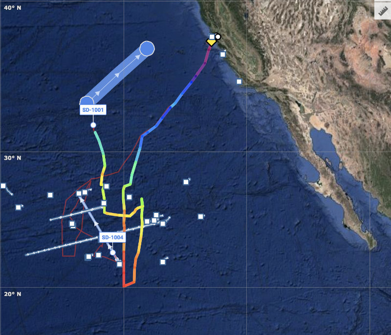
In the case of NWFSC’s Summer Survey and the SWFSC’s Coastal Pelagic Species Survey, the seven Saildrone Explorers sailed parallel transects up and down the US West Coast, augmenting the NOAA ships Bell M. Shimada and Reuben Lasker.
“It was a highly coordinated mission. We had to actively track the ships and adapt to conditions. Sometimes the wind died and the saildrones fell behind and sometimes there was so much wind they got ahead. Occasionally, we received a communication that said, ‘We found hake at this location, continue another three miles,’ so we retasked the saildrone to continue three more miles. We’re constantly adapting,” explained Ken Neal, Saildrone’s Director of Mission Management.
The diurnal vertical migration adds another level of complication to the West Coast fisheries missions. The mission was concerned with the daytime location of Pacific hake and other coastal pelagic species. So Saildrone mission managers stopped the USVs from sunset to sunrise. That doesn’t mean they deploy an anchor; they are put in a station. Mission operators create a geographic circle and task the saildrone to stay in the circle.
Weather events also require active mission management: Shortly after the two saildrones on the TPOS mission were deployed, there was a hurricane heading toward Hawaii. The Mission Control team had to evaluate whether or not to get out of the way (ultimately, they didn’t have to).
“There are times when a particular mission, whether because of the mission objectives or the conditions, requires very active management, but most of the time we program the route and monitor the saildrones’ progress making minimal updates as needed,” said Neal.
In addition to monitoring the physical progress of the USVs, Saildrone mission managers are also actively monitoring the data, which means making sure the sensors are functioning properly and immediately trouble-shooting any that behave atypically. Mission research partners can track the progress of the vehicles, view real-time data, and communicate with mission managers in the Saildrone Mission Portal.

“Each saildrone is well supported and the Mission Portal provides an amazing level of transparency,” said Neal. The overall objective is to allow our science users to focus on the science instead of troubleshooting hardware or having to learn complex new operational skills to collect the data they need.
Participating scientists can view real-time data on the Mission Portal and download daily summaries provided in NetCDF format. Some data sets are made available on specific thematic or regional data portals including NASA PO.DACC, NOAA ERDDAP, EMODNET, SOCAT, SOOS, or ICES.
There are currently more than 30 saildrones operating on missions around the world, from the Arctic to the Antarctic, and new missions are launched regularly. For updates on Saildrone missions as well as mission photos, reports, and announcements, follow us on Facebook,Twitter, or LinkedIn.
Must Read


[
NEVER MISS AN UPDATE
]
Stay informed with the latest research findings and updates.
By clicking Sign Up you're confirming that you agree with our Privacy Policy.
