The data collected will enhance understanding of habitats, geohazards, and oceanographic conditions across 13,000 square nautical miles in the northwestern Pacific Ocean.
Mapping the Mariana Islands: Saildrone Partners with Woolpert to Survey Critical Maritime Region for NOAA
Published on
February 24, 2026
Read time:
5
Minutes
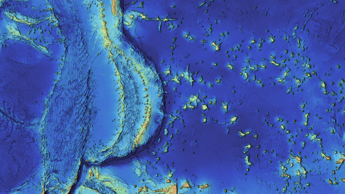
The Mariana Trench and the surrounding island chain represent one of the least mapped and most geologically significant regions of the world’s oceans. The Mariana Trench reaches the deepest depths of the world’s oceans, known as Challenger Deep, at 10,935 meters (35,876 feet) below sea level.
Accurate seafloor data in this region is foundational not only for understanding extreme ocean environments and marine biodiversity, but also for safe navigation and analyzing tectonic plates that cause tsunamis and earthquakes.
Saildrone, the global leader in autonomous seafloor mapping, and Woolpert, a leading provider of lidar and sonar bathymetry data, have partnered to acquire and process bathymetric survey data for the for the National Oceanic and Atmospheric Administration (NOAA)'s Ocean Exploration and Office of Coast Survey in support of the National Strategy for Mapping, Exploring, and Characterizing the United States Exclusive Economic Zone (EEZ) and Seabed 2030 initiative, which seeks to compile a complete map of the ocean floor. The Mariana Islands and the Mariana Trench make this region a top priority for seafloor mapping because of the opportunities for data collection they offer, and because the immense depths have made it challenging to obtain high-quality mapping data.
Woolpert Maritime Market Director Dave Neff said the partnership shows how autonomous technologies are transforming the acquisition of hydrographic data for deep-ocean exploration.
“By integrating Saildrone’s mission portal with Woolpert’s automated survey production environment, we gain real-time visibility into acquisition progress and data quality—especially in deep-water regions that were once difficult and costly to access,” Neff said. “This collaboration shows how uncrewed systems and smart partnerships can expand what’s possible in ocean mapping.”
High-resolution bathymetry underpins everything from marine habitat management and renewable energy siting to subsea cable routing and maritime navigation. Comprehensive mapping of the US EEZ also enhances long-term maritime resilience by ensuring that critical seabed terrain is understood, documented, and accessible to decision-makers.
The data collected will enhance NOAA’s understanding of sensitive habitats, marine geohazards, oceanographic conditions, and ecosystem management within the US exclusive economic zone in the vicinity of the Mariana Islands. It will also support sustainable energy development and help expand taxonomic reference libraries for understudied marine organisms. The contract is underway and is expected to conclude in May 2026.
The right platform for the mission
To accomplish this mission, Saildrone has deployed a 20-meter Surveyor unmanned surface vehicle (USV) designed for persistent, autonomous deep-ocean mapping and maritime domain awareness. The Surveyor is equipped with the industry-leading Kongsberg EM 304 MKII deep water multibeam sonar. As the Saildrone Surveyor methodically surveys the 13,000-square-nautical-mile region, it will relay data back to Woolpert in near-real time for processing and final delivery.
The Saildrone Surveyor operates autonomously and delivers high-resolution bathymetric data in the world’s most challenging environments. Powered by a high-efficiency diesel engine augmented by the patented Saildrone Wing, the vehicle leverages auxiliary wind energy to maximize fuel efficiency. This dual-source power architecture enables the extreme range and persistence necessary for autonomous long-duration maritime surveillance and deep-water ocean mapping. The Surveyor is one of three classes of Saildrone USV that have been tested and proven through operations globally for more than a decade.
“The seafloor mapping and exploration data that the Saildrone Surveyor collects around the Mariana Islands will close critical bathymetric gaps in the United States’ Exclusive Economic Zone,” said Brian Connon, vice president of ocean mapping at Saildrone. “The Surveyor’s ability to remain at sea for months at a time, regardless of weather conditions or sea state, makes it an ideal platform to carry out this vital work. Saildrone is proud to be working with both Woolpert and NOAA in these crucial efforts to better understand our ocean, marine resources, and ecosystem.”
Boosting the range and reach of hydrography
Saildrone’s use of unmanned surface vehicles creates new and exciting job opportunities for hydrographers. By utilizing platforms such as the Saildrone Surveyor to collect bathymetric and mapping data, Saildrone creates new employment models for hydrographers to contribute to rigorous data acquisition, analysis, and quality workflows in a fully remote environment. Saildrone platforms can operate 24/7, with a globally dispersed staff working from shore, significantly reducing both personnel risk and overall survey costs.
Comprehensive seafloor knowledge strengthens more than scientific understanding—it supports maritime safety, infrastructure resilience, and informed decision-making across government and industry. In an era when subsea terrain plays an increasingly important role in navigation, energy development, and communications infrastructure, accurate bathymetry is a strategic asset.
Saildrone’s proven deep-ocean platforms, operational track record, and bathymetric expertise, combined with Woolpert’s advanced data processing capabilities, enable efficient, high-resolution mapping at scale. Together, the partnership demonstrates how autonomous systems are expanding the reach of hydrographers and accelerating progress toward a fully mapped ocean.
Must Read


[
NEVER MISS AN UPDATE
]
Stay informed with the latest research findings and updates.
By clicking Sign Up you're confirming that you agree with our Privacy Policy.
