This first-of-its-kind acoustic bathymetry mission will test the ability of Saildrone USVs to map the US exclusive economic zone off Alaska’s North Slope.
Mapping the Arctic Seafloor Using Autonomous Vehicles
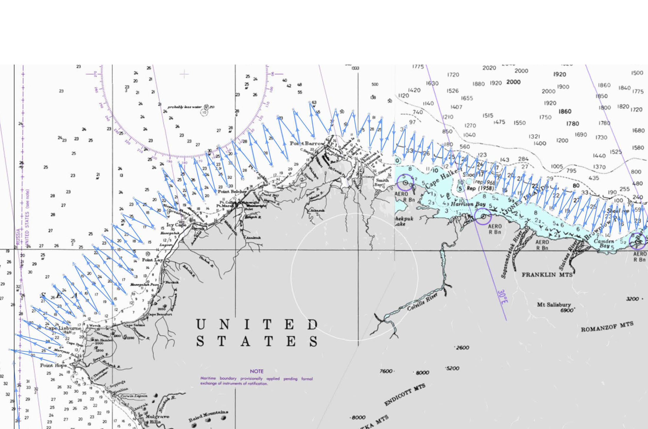
Map showing the general survey area along Alaska’s North Slope from Point Hope to the Canadian border.
Published on
June 11, 2020
Read time:
5
Minutes
Exploration of the Northwest Passage, the Arctic sea route between the Atlantic and the Pacific, began even before the Panama Canal was built. It was a treacherous journey—along the west coast of Greenland, weaving through Canada’s Arctic islands, and then southwest along Alaska’s North Slope and through the Bering Strait—and even in the summer, it was mostly blocked by impenetrable sea ice. Today, due to climate changes in the Arctic and a retreating ice cap, the Northwest Passage could become an economically viable shipping route, however, it remains very shallow and dangerous, and chart data is limited and antiquated.
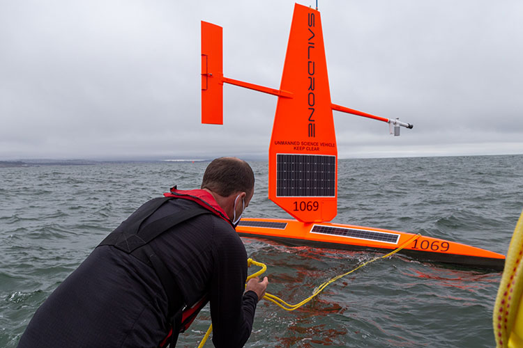
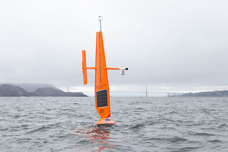
This summer, four Saildrone unmanned surface vehicles (USVs) are sailing from San Francisco to the Chukchi Sea to perform a proof-of-concept acoustic single-beam bathymetry mission supporting the National Oceanic and Atmospheric Administration (NOAA)’s effort to provide modern, accurate mapping data of the Bering Sea and Alaska’s North Slope.
The 2020 Arctic Mapping mission is the first step toward resolving major gaps in Arctic charts and Saildrone’s first reconnaissance survey to provide modern, accurate charting data, in collaboration with TerraSond on behalf of NOAA’s National Ocean Service (NOS).
The transit distance between Asia and the US West Coast and Europe via the Northwest Passage is estimated to be around 1,000 nautical miles shorter than through the Panama Canal. Many ships and their crews have perished in icy Arctic waters throughout the history of Northwest Passage exploration.

“Accurate bathymetry of the Arctic seafloor is key to maritime safety, economic development, and sustainability efforts in the region. This first Saildrone USV fleet will make high-resolution mapping of the Arctic cost-effective at scale while limiting risk to human health and safety in those remote regions,” said Saildrone CEO Richard Jenkins.
Saildrone typically launches Arctic missions out of Dutch Harbor, AK. Due to COVID-19 travel restrictions, the four saildrones were deployed from Saildrone HQ in Alameda, CA. The transit to the survey area will take approximately 60 days, sailing across the North Pacific Ocean and through the Bering Sea. After continuing through the Bering Strait and entering the Chukchi Sea, the USVs will separate into two fleets of two, one group starting on the western North Slope and the other group transiting to the eastern North Slope.
The four saildrones are equipped with Airmar DT800 depth sounders to measure the depth of the seafloor (bathymetry) using sound. Over a two-month period, they will perform a zig-zag pattern with a spacing of no more than five nautical miles between passes to delineate a corridor between the 20-meter and 50-meter contour lines (isobaths) to encourage navigation of commercial vessels, as well as identify any unique depth observations. The survey area will extend from north of Point Hope, AK, northeast to the Canadian border. The saildrones may also perform survey grid patterns to demonstrate a full concept of operations for future potential autonomous multibeam surveys of the Arctic.
While Saildrone USVs operate autonomously, they are remotely monitored by Saildrone Mission Control 24/7, and the mission can be adapted or adjusted on the fly; the exact timing and survey pattern of the Arctic Mapping mission will be adjusted in real time according to ice conditions. TerraSond, with over 20 years of experience in hydrographic and marine geophysical mapping and charting, and a wealth of experience in the Arctic, will support survey planning and coverage as well as data processing for the mission.
“This Arctic deployment is the first dedicated hydrographic mission for Saildrone,” said Rear Adm. Shepard Smith, director of NOAA’s Office of Coast Survey (OCS). “I am excited about the role unmanned systems will play in Arctic seabed mapping.”
Saildrone has worked with NOAA’s Pacific Marine Environmental Laboratory (PMEL) and Alaska Fisheries Science Center (AFSC) in the Arctic over the past half-decade to integrate and operationalize single-beam echo sounder technology on its wind-powered autonomous platform to conduct fisheries missions. The quality of the data from the echo sounder has been demonstrated to be excellent in comparison to ship and buoy data, and past survey data has been incorporated into NOAA charts.
In the Gulf of Mexico, Saildrone is working with NOAA’s Office of Coast Survey (OCS) and the University of Southern Mississippi (USM) to integrate single-beam and multibeam acoustic technology for shallow-water and coastal bathymetric missions to a depth of 200 meters. Saildrone USVs have successfully mapped multiple remote seamounts and identified the remains of an uncharted shipwreck, helping to improve safety of navigation through more accurate characterization of shallow underwater features.
Saildrone is also developing a scaled-up version of the platform, the 22-meter (72-foot) Saildrone Surveyor (SDS). This medium unmanned surface vehicle (MUSV) will have a 15-meter (50-foot) tall wing and a one-ton payload powered with more than 5,000 W of solar panels along with a backup high-efficiency generator and electric thruster. This platform is being developed through a public-private partnership with the University of New Hampshire (UNH) and the Monterey Bay Aquarium Research Institute (MBARI) with the support of a grant from the NOAA Office of Ocean Exploration and Research (OER) via the National Oceanographic Partnership Program (NOPP).
The US exclusive economic zone (EEZ) is the largest in the world, extending 200 nautical miles offshore and spanning over 21,000 kilometers (13,000 miles) of coastline. The total area of the US EEZ is some 3.4 million square nautical miles—larger than the combined area of all 50 states—and includes a diverse array of ecosystems and vast natural resources, such as fisheries, energy, and other mineral resources. In November 2019, the White House issued a presidential memorandum calling for the mapping of the Alaska shoreline and nearshore seafloor to improve understanding of ocean resources and advance economic, security, and environmental interests.
Earlier in May, three other saildrones were deployed from Alameda to sail to the Bering sea to perform the annual Alaska pollock survey on behalf of NOAA Fisheries.
Must Read


[
NEVER MISS AN UPDATE
]
Stay informed with the latest research findings and updates.
By clicking Sign Up you're confirming that you agree with our Privacy Policy.
