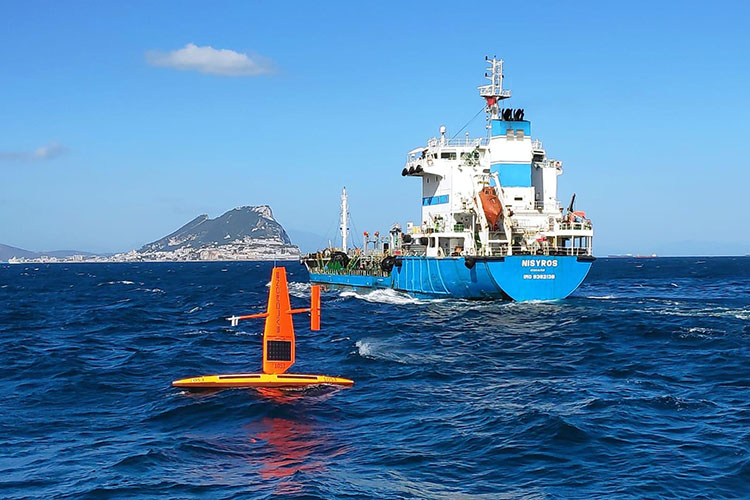
SD 1030 and SD 1053 reverse the path of the ancient mariners, entering the Mediterranean Sea through the Pillars of Hercules.
Saildrones Complete First Unmanned Passage of Strait of Gibraltar

Published on
March 6, 2020
Read time:
5
Minutes
The word ocean comes from the Ancient Greek ὠκεανός (ōkeanós), which means “great river.” When the Greeks first ventured out of the Mediterranean Sea through the Strait of Gibraltar some 3,000 years ago, they noticed a significant current running north to south and assumed that the Atlantic Ocean was a great river that encircled the world. The Strait of Gibraltar is the only natural connection between the Mediterranean Sea and the world’s oceans inspiring myths and legends since ancient times. The entrance is marked by the Pillars of Hercules—the Rock of Gibraltar and Jebel Musa—created, according to the Romans, when Hercules smashed the Atlas Mountains apart. Since the Renaissance, it’s been said that Hercules placed the inscription non plus ultra (nothing lies beyond) on the pillars as a warning to sailors that the end of the world was near.
Today, the 31-nautical mile (58-kilometer) passage between Europe and Africa is one of the busiest waterways in the world. The strait is only seven nautical miles (13 kilometers) across at its narrowest and 23.7 nautical miles (44 kilometers) at its widest. Approximately 300 ships cross it every day, about one ship every five minutes. Add to that dozens of fishing boats and recreational vessels. And, on March 6, 2020, at approximately 16:16 UTC, two Saildrone unmanned surface vehicles (USVs) completed the first autonomous passage of the Strait of Gibraltar.


SD 1030 and SD 1053 were escorted by a patrol boat from the Spanish Armada’s Instituto Hidrográfico de la Marina (IHM) and a research vessel from the University of Cadiz throughout the nine-hour passage. The saildrones were deployed from a facility in the Canary Islands operated by the Oceanic Platform of the Canary Islands (PLOCAN) in October on a six-month mission to survey eddies and air-sea carbon fluxes and perform cross-calibrations with European Research Infrastructure (RI) sites in the Atlantic Ocean and Mediterranean Sea. The Strait of Gibraltar passage is a significant milestone on the ATL2MED mission.
Local topography and biogeochemistry contribute to usually rough conditions for passage and support abundant sea life. Easterly or “levanter” winds arise in the central Mediterranean and reach their greatest intensity through the strait; the narrow gap in the mountains to the north and south acts like a funnel through which the pressure consolidates. Winds that are moderate over the Alboran Sea on the eastern side of the strait can become gale force on the western side. Levanters can occur at any time of year but are most frequent April to October.

The tides and currents through this narrow inlet are incredibly complex. The water in the Atlantic Ocean is less saline and therefore less dense than that of the Mediterranean Sea. Currents through the Strait of Gibraltar are primarily caused by an exchange of water of different salinities; a surface layer of water—to a depth of 125 meters (410 feet) on average—flows into the Mediterranean from the Atlantic at an average speed of two to three knots (3.7 – 5.5 kph). Tidal flows up to four knots (7.4 kph) can either speed up or slow down the eastward surface current. Conditions in the strait are the roughest when the current is at its max speed and a levanter is blowing against it.
The exchange of water of different salinities and tidal interaction with topography near the Camarinal Sill, the shallowest area of the seafloor between the Iberian Peninsula and Africa, causes a high amplitude internal wave, upwelling of nutrient-rich water and attracting whales, dolphins, and turtles to the region, despite the heavy traffic.
“I first sailed through the Strait of Gibraltar when I was 17, on a sailboat, after crossing the Atlantic from Bermuda. I remember it well, complex currents, choppy seas, and an incredibly busy shipping lane, which took the entire crew’s attention to navigate safely. I could not have imagined then, that 26 years later, we would be sending unmanned autonomous vehicles through that same piece of water, actively supervised from a control center 5,000 miles away in California,” said Saildrone founder and CEO Richard Jenkins.
“This is another significant accomplishment for the Saildrone fleet and demonstrates our vehicles are just as comfortable in the ice of the Arctic, the huge storms of the Southern Ocean, or one of the most confined and busy shipping lanes in the world. We are thrilled to have achieved this milestone and to move on to the next stage of the mission, our first sailing in the Mediterranean. I’d like to thank the local authorities, the PLOCAN staff, and the University of Cadiz for their assistance with logistical support and escorting the vehicles through the strait,” added Jenkins.

Saildrone was born out of a 10-year research and design project to break the world land speed record and has continued its record-breaking tradition ever since. In October 2013, an early-design saildrone nicknamed Honey Badger completed the first unmanned Pacific crossing, sailing 2,248 nautical miles in 34 days from San Francisco to Hawaii. Saildrone USVs are the first autonomous vehicles to navigate the Bering Strait, circumnavigate Antarctica, and complete eastbound and westbound Atlantic crossings.
ATL2MED is a public-private partnership between Saildrone and 12 oceanographic and research institutions from seven countries and generously sponsored by PEAK6, a private technology and investment firm started by Jenny Just and Matt Hulsizer.
The mission began with an eddy survey led by the Helmholtz Centre for Ocean Research (GEOMAR) near Cabo Verde. The saildrones then sailed north to connect Integrated Carbon Observation System (ICOS OTC) stations in order to cross-validate carbon measurements between stations, including ESTOC and MONIZEE in the Atlantic Ocean. Having entered the Mediterranean, the two saildrones will continue their mission, heading northeast to study currents off the coast of Spain and the Balearic Islands followed by a study of air-sea carbon fluxes along the Nice-Calvi line. The mission is expected to conclude in Trieste, Italy, in the Adriatic Sea.
Must Read


[
NEVER MISS AN UPDATE
]
Stay informed with the latest research findings and updates.
By clicking Sign Up you're confirming that you agree with our Privacy Policy.
