Detailed seafloor mapping captures the intricate geomorphology of coral reefs, submerged karst, and shipwrecks, supporting coastal management.
Saildrone Completes Survey of “Middle Grounds” for the Florida Seafloor Mapping Initiative
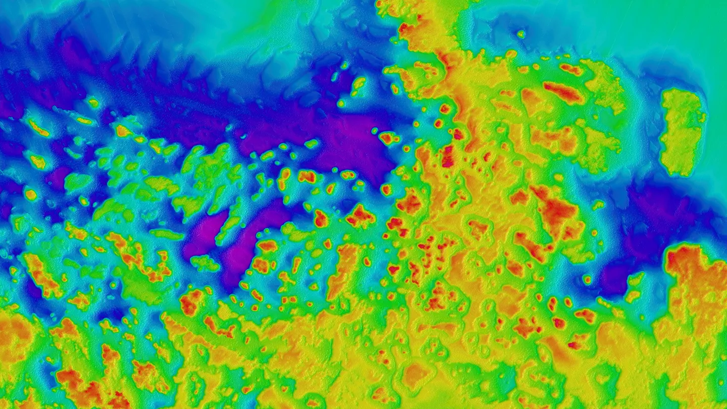
Multibeam data collected by Saildrone in the Gulf of America for the Florida Seafloor Mapping Initiative.
Published on
April 27, 2026
Read time:
5
Minutes
Florida’s coastal waters drive billions of dollars each year in tourism, recreation, and commerce. From managing fisheries and protecting marine habitats to planning critical infrastructure like communications cables and safeguarding coral reefs that support tourism, what happens offshore influences the Sunshine State’s economic engine.
Properly managing these resources depends on acquiring high-resolution bathymetric data that accurately maps the seafloor’s depth and features. This information helps identify sensitive habitats, chart safe routes for commercial vessels, and inform conservation decisions.
In support of the Florida Department of Environmental Protection’s (FDEP) efforts to better understand and manage its coastal waters, Saildrone completed a bathymetric survey of a 2,800-square-kilometer region approximately 70 nautical miles off the state’s western coast known as the “Middle Grounds.” The work was conducted as part of the Florida Seafloor Mapping Initiative (FSMI) using two Saildrone Voyager unmanned surface vehicles (USVs). The mission’s success was enhanced by IIC Technologies’ professional expertise, which provided third-party hydrographic support throughout the survey.
.webp)
Saildrone delivered the survey data to FDEP in February, providing high-resolution bathymetric measurements collected by two Voyager USVs equipped with NORBIT Winghead i80S multibeam echo sounders. Located within Florida’s ancient paleoshoreline, the survey area featured a complex geomorphology of coral reefs and submerged karst, complemented by the presence of several shipwrecks. The resulting data supports FSMI’s broader effort to give stakeholders a detailed view of the seafloor across Florida’s continental shelf.
“High-resolution seafloor mapping is crucial to supporting Florida’s blue economy, influencing everything from coastal resilience to safe maritime commerce, and recreational fishing to coral reef protection,” said Brian Connon, Saildrone vice president of ocean mapping. “By deploying Voyager USVs, we can map complex environments like the Middle Grounds more efficiently and with less environmental impact than traditional methods, providing the critical data the state needs to protect its coastal infrastructure and natural resources.”
Built for long-endurance, shallow-water mapping missions, the Saildrone Voyager is a 10-meter USV that enables hydrographic teams to collect high-resolution bathymetry without the constraints of traditional survey ships. The platform helps extend survey windows across adverse weather and sea conditions, with data continuously transmitted to shore-based hydrographers for monitoring and processing.
Saildrone is applying that same operational model across a growing range of coastal and remote seafloor mapping missions.
3D data fly-through of the seafloor showing reef mounds that make up the Florida Middle Grounds. Designated as a federally protected Habitat Area of Particular Concern (HAPC), the area is known for its flourishing fishing grounds. The area is geologically rich, with a large reef complex that reaches up to 15 m of relief in some places. The Middle Grounds formed ~10,000 years ago. Unlike the well-known coral reefs of the Florida Keys, these reefs were largely made by a type of snail called vermetid snails that lived between ~8,000 – 10,000 years ago and then died off due to rising sea levels.
Supporting national ocean mapping priorities
FSMI builds on the Florida Coastal Mapping Program (FCMaP), a multi-agency effort led by federal and Florida state partners to generate a comprehensive, high-resolution seafloor dataset of Florida’s coastal waters by 2028.
“Florida’s coastline is one of our state’s greatest natural and economic assets, supporting millions of residents, tourism, commercial fisheries, and critical infrastructure,” said DEP Secretary Alexis A. Lambert in a recent press release. “Understanding the seafloor and the features that shape our coast helps us make smart decisions about protecting communities, strengthening resilience, and investing taxpayer dollars where they will have the greatest impact.”
Florida’s work is part of a broader nationwide effort to expand and modernize high-resolution seafloor maps of US waters. Saildrone is supporting that goal both close to shore and in remote regions where traditional survey operations can be logistically challenging, costly, or high-risk. Most recently, Saildrone partnered with Woolpert, a leading provider of lidar and sonar bathymetry data, to acquire and process bathymetric survey data for NOAA across roughly 13,000 square nautical miles around the Mariana Islands.
While the Saildrone Voyager is optimized for coastal and continental-shelf mapping, the mission around the Mariana Islands is using the Saildrone Surveyor, a 20-meter USV designed for persistent, autonomous deep-ocean mapping. Both platforms leverage the Saildrone Wing to harness wind energy and improve energy efficiency, extending range and endurance for long-duration maritime surveillance and ocean mapping missions.
Through projects in Florida and the Mariana Islands, Saildrone is helping advance the National Strategy for Ocean Mapping, Exploring, and Characterizing the United States Exclusive Economic Zone, expanding access to modern seafloor mapping products that support science, safety, and ocean planning.
Florida’s coastal waters and the ecosystems they support underpin many of the state’s industries. Initiatives like FSMI help close persistent mapping gaps and provide decision makers with actionable knowledge for fisheries management, infrastructure routing, and safe navigation.
Saildrone is uniquely positioned to deliver this capability at scale. Using USVs like the Voyager and Surveyor, Saildrone extends high-resolution bathymetry into environments where traditional approaches can be slower, more expensive, or operationally constrained. The result is efficient, repeatable seafloor mapping that supports science, safety, and ocean planning in Florida and across US waters.
Must Read


[
NEVER MISS AN UPDATE
]
Stay informed with the latest research findings and updates.
By clicking Sign Up you're confirming that you agree with our Privacy Policy.
