Published on
Author
In January 2020, Saildrone deployed a fleet of five unmanned surface vehicles (USVs) from Barbados to participate as part of a two-month field study to advance the understanding of how the ocean and atmosphere interact. The mission was a part of two complementary international initiatives led by US and European science organizations: EUREC4A (Elucidating the Role of Cloud-Circulation Coupling in Climate) and ATOMIC (Atlantic Tradewind Ocean-Atmosphere Mesoscale Interaction Campaign) with additional participation from the National Aeronautics and Space Administration (NASA) Physical Oceanography program. This massive coordinated effort involved an impressive array of observing platforms: satellites, aircraft, research vessels, buoys, floats, drifters, gliders, and the saildrones.
There were two primary survey areas: East of Barbados and approximately two days southeast of Barbados off the coast of French Guiana. Four of the five saildrones sailed south with the RVs Atalante and Maria S Merian measuring mesoscale and submesoscale structures over a large portion of the ocean while the fifth saildrone stayed closer to Barbados.
Saildrones can be operated individually or as a fleet, sailing precise mission tracks or holding station. During the mission, the four saildrones working with the Atalante performed advanced formation sampling in parallel with the ship and around the ship.
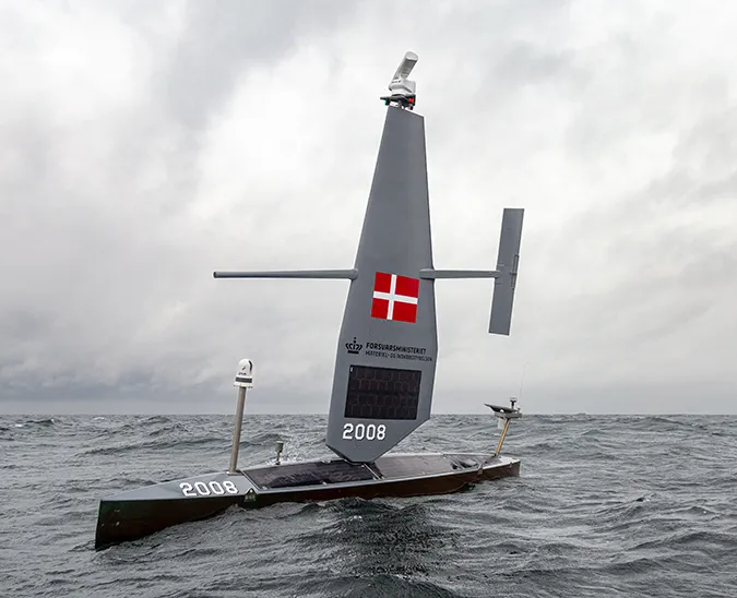
Saildrones sailing in parallel formation in the Atlantic Ocean. Courtesy Dr. Sabrina Speich.
“There is a lot to be learned about sub-mesoscale variability by sailing the saildrones in close formation. Saildrones can act in two ways: They can hold station, acting similarly to a buoy, or they can be used in a coordinated manner to understand sub-mesoscale variability,” explained Dr. Chelle Gentemann, a senior research scientist at The Farallon Institute who worked with Saildrone Mission Control to task the saildrones during the mission.
Sub-mesoscale variability in the ocean is typically understood to be under 100 kilometers (62 miles). Saildrones are capable of sampling features around 1 kilometer (.6 miles) with the high temporal and spatial resolution required to understand ocean and atmosphere dynamics.
The RV Atalante worked directly with the saildrones on several occasions.
“One time, we stayed on station in parallel with the saildrones for three or four hours so that we could measure the wind and ocean currents, air-sea fluxes, temperature, and salinity at the same time over a small distance. On another occasion, the saildrones were sailing a concentric square around the ship, which was holding station in the center,” said Dr. Sabrina Speich, a physical oceanographer at France’s Laboratoire de Météorologie Dynamique and one of EUREC4A’s principal investigators (PIs) who was onboard the Atalante.

NASA’s primary interest in the mission was to examine how air-sea interactions over ocean eddy structures impact the lower boundary layer, as well as looking at how high temporal and spatial resolution observations from the saildrone can improve understanding of uncertainty in satellite analyses.
On the ship, Speich and her team were using primarily satellite altimetry to identify surface eddies, but when they began sampling with the saildrones, they discovered sub-surface structures that did not have an imprint on the surface. The saildrones are particularly adept at measuring the layers between the atmosphere and upper ocean, layers that are not as easily observed by ship-based instruments.
“We came on this by chance and the saildrones allowed us to measure them. We’ll have a really nice matching on the dynamics of the ocean, how the sub-surface dynamics work with the surface and how the surface ocean works with the atmosphere, and also in terms of the biogeochemistry, CO2 uptake, heat uptake, and energy exchange. This is really important because it will help to improve not only numerical weather prediction models but also climate models, and shed light on new physical processes,” said Speich.
With the ships and saildrones back in port, the scientists will now begin to analyze the data. The larger goal is to take a deep look into these processes over space and time across a variety of disciplines, which is likely to produce a number of papers over the next several years.
Two of the five saildrones will continue to collect data in the vicinity of Barbados as part of ATOMIC, while another set of saildrones is working in the Mediterranean Sea as part of the 2019-2020 ATL2MED mission.