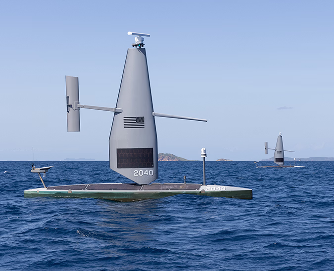
Four Saildrone Explorer USVs deployed to the tropical Pacific, where they will work in conjunction with the Tropical Pacific Observing System and NOAA researchers to monitor this year’s unusually strong El Niño.
Saildrone and NOAA Return to the Tropical Pacific to Track a Powerful El Niño

One of four Saildrone Explorers sails south from Honolulu, on a 1,100 nm transit to the mission operation area at the equator.
Published on
September 9, 2026
Read time:
5
Minutes
Forecasters expect a monumental El Niño this year, and communities around the world are already experiencing its effects. This tropical Pacific climate phenomenon disrupts the lives of billions—stunting maize harvests in Africa, delaying rice sowing in Asia, and threatening shipping traffic in the Panama Canal.
To monitor sea surface and subsurface conditions, the National Oceanic and Atmospheric Administration (NOAA) relies on the Tropical Pacific Observing System (TPOS). This multinational array of data-collecting moored surface buoys, free-floating Argo floats, drifters, and satellites spans the tropical Pacific, including the Niño 3.4 region, a section of ocean scientists use as a key measure of El Niño’s strength. The name “Niño 3.4” stems from a conclusion by scientists that overlapping sectors of two regions—named Niño 3 and Niño 4—offer the best indicators about the El Niño’s overall strength.
This infrastructure provides continuous, real-time hourly tracking of surface winds, air temperature, humidity, and upper-ocean temperature down to 500 meters (1,640 feet). But these assets have their limitations. Moored buoys are positioned hundreds of nautical miles apart, leaving meaningful gaps in the fine-scale atmospheric and oceanic data available to scientists, including observations of the boundaries between warmer and cooler water.
Saildrone, working in partnership with NOAA’s Pacific Marine Environmental Laboratory (PMEL), recently deployed four Saildrone Explorer unmanned surface vehicles (USVs) on a four-month, 6,000-nautical-mile round-trip mission to the tropical Pacific. The USVs carry a suite of scientific sensors designed to measure the ocean and atmospheric processes that drive El Niño and influence weather patterns around the world. This deployment marks the eighth joint TPOS mission for Saildrone and PMEL since the initiative was first launched in 2017.
“The disruptions triggered by major El Niño events have global ramifications—from shipping delays and reduced agricultural yields to drought, flooding, and other extreme weather events. These are not simply environmental challenges; they are national and economic security issues,” said Matt Womble, vice president of government relations at Saildrone. “This long-standing partnership matches the unparalleled endurance and resilience of Saildrone's unmanned surface vehicles with NOAA’s world-renowned expertise to deliver accurate, real-time observations from the equatorial Pacific—allowing scientists to better understand El Niño and forecast its global impacts.”
Saildrone data will be transmitted back to researchers in near real time to aid in mapping boundaries between warm and cool waters and to cross-calibrate observations from other platforms. A subset of the data will also be transmitted via the Global Telecommunication System to operational forecast centers to improve NOAA’s global and US weather forecasts.
Four Saildrone Explorers were deployed from Honolulu, Hawai'i, for the 2026 Saildrone/NOAA TPOS mission.
Observing El Niño where it develops
El Niño begins in the equatorial ocean region where weakening trade winds allow warm waters to move eastward and meet usually cool water, resulting in an enormous relocation of ocean heat. This stretch of the central Pacific is critically important for observation because the unique air-sea interactions taking place drive changes in global weather patterns.
Satellites, buoys, and floats help scientists capture this data, but ultimately leave meaningful gaps. Historically, collecting targeted observations to fill these spaces required months of planning, expensive research vessels, and teams of scientists spending months at sea.
“Moorings, satellites, and other TPOS components cannot fully quantify the boundaries of these warm water masses,” said Meghan Cronin, a NOAA PMEL lead oceanographer working with Saildrone. “When we steer the saildrones directly through those boundaries, we map their exact positions and structures. This high-resolution profiling allows us to observe how these ocean fronts correlate with atmospheric and biogeochemical variables like winds, air temperature, and carbon dioxide, helping us understand how the ocean and atmosphere interact within the Niño 3.4 region.”
The 7-meter Saildrone Explorer fills this capability gap by bringing an advanced suite of sensors directly to the areas scientists need to study. The Explorer has a proven track record in some of the world’s most demanding ocean conditions, from hurricanes in the Atlantic to the high winds and seas of the Southern Ocean.
The ability to transit to the Niño 3.4 region, remain on station for months at a time, and dynamically reposition in response to atmospheric changes or NOAA’s operational needs makes the Saildrone Explorer an ideal tool to supplement data coming from TPOS’s existing infrastructure.
Built for endurance, designed for flexibility
For this mission, the four Saildrone Explorer USVs carry certain specialized payloads, in addition to the standard suite of sensors designed for meteorological and oceanographic (METOC) observations.
All four USVs measure wind speed and direction, air temperature, humidity, barometric pressure, sea surface temperature, and salinity, among other variables. These readings collectively provide scientists with a fuller picture of the ocean and atmosphere in the El Niño 3.4 region, which furthers their understanding of El Niño’s potential impacts in the coming months.
Two of the four USVs carry an Autonomous Surface Vehicle Carbon Dioxide (ASVCO2) sensor to track how El Niño alters the global carbon cycle. NOAA’s PMEL developed this instrument to measure carbon dioxide levels right where the ocean meets the air. Normally, the upwelling process pulls cold, carbon-rich water to the surface, where it releases carbon dioxide into the atmosphere. During an El Niño, however, this rising water slows or stops entirely, halting the release of the gas. By capturing automated, real-time measurements across these changing boundaries, the ASVCO2 sensor helps scientists track how carbon moves between the ocean and atmosphere and better understand how El Niño affects the ocean’s role in the global carbon cycle.
From the Pacific Ocean to the global forecast
The historically strong El Niño developing in the tropical Pacific Ocean could potentially trigger severe downstream weather disruptions across the globe, from catastrophic flooding in the southern United States to intense droughts in Australia. The longstanding partnership between Saildrone and NOAA combines the world’s most operationally proven USV with world-class expertise to observe, study, and better understand the consequences of El Niño.
By filling gaps in the existing TPOS network, Saildrone USVs give researchers a more detailed view of the complex atmospheric conditions and changes happening across the tropical Pacific. Those observations improve forecasts of El Niño’s global effects, helping governments and industries better prepare for disruptions to agriculture, shipping, infrastructure, and severe weather—all of which carry significant national and economic security consequences.
Resources
NOAA Research, “NOAA Dispatches Saildrones to Probe the Engine of El Niño,” NOAA Research, September 3, 2026


[
NEVER MISS AN UPDATE
]
Stay informed with the latest research findings and updates.
By clicking Sign Up you're confirming that you agree with our Privacy Policy.